Geo.be, het federale geoportaal
Geo.be is de toegangspoort bij uitstek voor de geografische informatie van de Belgische federale instellingen.

The WMTS definition in version v2026.03 of CartoWeb.be, published on 20 October, includes two inherent changes compared with previous versions. This is why, if you use the WMTS version of CartoWeb.be in your own web and mobile applications, action is required before 1 December 2026 to rule out any risk of problems when using and publishing CartoWeb.be via your tools.
The information in this note will enable you to make the necessary changes in a controlled, planned manner.
A pyramid is created to structure all caches and ensure coherence and geo-referencing between the different scale levels. This pyramid is implemented using Tile Matrix Sets, as defined in the Open GeoConsortium Web Map Tile Service (1.3.0) standard. A Tile Matrix Set is a reference system that divides space into Tile Matrices at different scales, which in turn divide an area into tiles. This information is defined in the metadata of the service, which can be accessed via the GetCapabilities request.
Versions prior to v2026.03 included 3 pyramids/Tile Matrix Sets: 3857, 3812 and 3812_crossborder. Version v2026.03 of CartoWeb.be only offers two: 3812 and 3857, for all 5 of its components (TOPO, TOPO-GREY, OVERLAY, CROSSBORDER and CROSSBORDER-GREY).
Within the WMTS version of the service, the elimination of Tile Matrix Set 3812_crossborder is characterised by:
We invite you to update your clients’ configuration to adjust the source and URL for the tiles (constructed using the Tile Matrix Set) by referring to the data available in the GetCapabilities of the beta service.
Below are the settings that have been changed in version v2026.03:
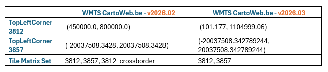
To enable you to implement these changes and minimise the risk of disruption, the NGI is rolling out the update in three phases:
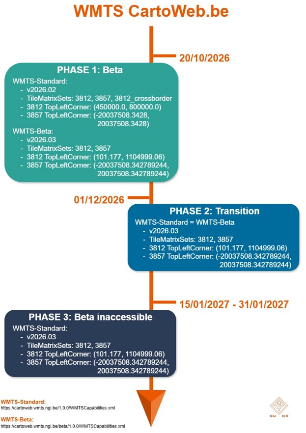
Phase 1, from today (20/10/2026): version v2026.03 (WMS and WMTS), containing the most up-to-date data and defined in accordance with the new Tile Matrix Set parameters, is available via a temporary URL:
During this phase, the standard URL for CartoWeb.be will remain accessible. It will continue to display version v2026.02 of the service, as defined by the old Tile Matrix Set settings.
During this phase, you can prepare for and test the change within your applications.
Phase 2, scheduled for 1 December 2026: version v2026.03 of CartoWeb.be (defined in accordance with the new Tile Matrix Set parameters) will be migrated to the standard URLs. This means that, as of this date, both standard and beta URLs will display the latest version of CartoWeb.be, v2026.03.
If you changed the settings of your applications during the first phase, all you need to do at this stage is configure your tools to use the standard URL: https://cartoweb.wmts.ngi.be/1.0.0/WMTSCapabilities.xml
However, if you did not change the settings of your applications during the first phase, you will encounter a problem in this second phase: the service will not display the correct tiles.
Phase 3, end of January 2027: the beta URLs will be taken offline and the situation will return to normal. CartoWeb.be will only be accessible via the standard URLs, which will be updated every two months.
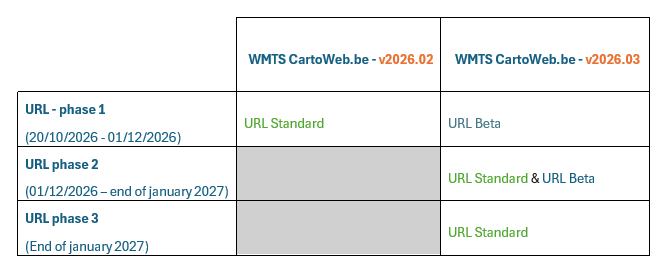
This table provides an overview of how versions v2026.02 and v2026.03 can be viewed via the Standard and/or Beta URLs throughout the 3 phases.
URL Standard : https://cartoweb.wmts.ngi.be/1.0.0/WMTSCapabilities.xml
URL Beta : https://cartoweb.wmts.ngi.be/beta/1.0.0/WMTSCapabilities.xml
To ensure a prompt response and an effective follow-up of your enquiry, we recommend that you contact the NGI at cartoweb@ngi.be.
Het Nationaal Geografisch Instituut biedt een aantal online resources aan die door het brede publiek gebruikt kunnen worden.
Oeps! Het ziet er naar uit dat je een verouderde browser gebruikt. Dit kan er voor zorgen dat deze website niet helemaal correct functioneert. We raden je ten sterkste aan om de laatste versie van je favoriete browser af te halen. Met een recente browser kan je op veilige en optimale wijze rondsurfen.